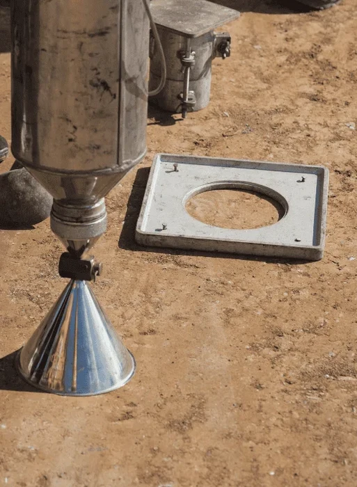
Cleveland sits at roughly 650 feet above Lake Erie, but what matters for compaction is the 50 to 100 feet of glacial till and lacustrine clay beneath the surface. Every trench backfill, every structural pad in the Flats, and every roadway subbase in University Circle has to meet density specs that shift with the soil type. We run field density checks with the sand cone apparatus because the method is direct, reliable, and fully traceable to AASHTO T 191. Unlike nuclear gauge readings that struggle in layered Ohio clays, the sand cone gives us a physical mass-volume measurement that holds up under third-party review. For jobs where the geotechnical baseline includes variable silt lenses—common from Collinwood west to Lakewood—we often pair the density test with Proctor tests to lock in the laboratory maximum dry density before any field verification begins. When fill lifts exceed two feet and the spec calls for 95 percent modified Proctor, the sand cone is the tool our inspectors trust on the critical lift sign-off.
A sand cone test measures mass and volume directly—no radiation, no calibration transfer curves, just a physical hole and a known sand density.
Scope of work in Cleveland
Typical technical challenges in Cleveland
Comparing the near-west-side Detroit-Shoreway neighborhood with the eastern Euclid Creek basin tells the whole story. Detroit-Shoreway sits on dense Wisconsinan till—compacts easily, drains reasonably, and hits 98 percent relative density with four passes of a smooth-drum roller. Euclid Creek bottomland runs on soft lacustrine silts and clays with natural moisture content above 25 percent; those fills fail density on the first test three times out of five, and the contractor ends up scarifying, aerating, and recompacting until the sand cone numbers climb above the 95 percent threshold. The real risk in Cleveland isn't just failing a density test—it's differential settlement that cracks sanitary laterals and tilts approach slabs within two freeze-thaw cycles. We've seen a single under-compacted utility trench in Ohio City settle 1.5 inches in nine months, pulling the asphalt patch into a pothole that the water department has to revisit. When the subgrade is marginal, we may bring in a vibrocompaction evaluation on deeper granular fills or recommend cement-stabilized backfill around manhole structures. The sand cone data, collected at the right frequency and with tight moisture tracking, is the only field measurement that catches density shortfalls before the pavement goes down.
Our services
Our Cleveland field density program covers the full cycle from lab Proctor reference curves through final lift acceptance. We work directly with site superintendents, earthwork subs, and third-party testing firms.
Earthwork Compaction Verification
Lift-by-lift sand cone testing for structural fill, utility trench backfill, and building pads. We follow ODOT 304 and City of Cleveland specs, providing real-time pass/fail results with moisture correction and immediate re-test coordination.
Pavement Subgrade & Base Acceptance
Field density checks on aggregate base courses and subgrade soils prior to asphalt or concrete paving. We integrate CBR road testing when the design calls for a stiffness-based acceptance alongside density compliance.
Quick answers
What does a sand cone density test cost on a typical Cleveland jobsite?
For projects within Cuyahoga County, a single sand cone test with lab moisture determination typically runs between US$100 and US$170. Volume pricing applies when we station a technician on-site for a full shift with multiple lifts.
How many sand cone tests are needed per lift in Cleveland's glacial clays?
The Ohio DOT specification generally calls for one field density test per 1,500 square feet per lift, with a minimum of three tests per lift. In variable ground—such as the layered silty clays common along the Cuyahoga River corridor—we tighten that to one test per 1,000 square feet to capture moisture and density shifts across short distances.
Can the sand cone method be used when the compacted surface is frozen?
Testing on frozen ground produces unreliable volume measurements because the sand cone base plate seats poorly and the excavation boundary is irregular. During Cleveland's winter months we either postpone the test until the lift has been covered and thawed, or switch to an alternative method after documenting the frozen condition in the field log.